Ibsley Common
Starting Point
Rockford Common car park (National Trust)
///stripped.gratuity.hood
Distance
3.5 MILES (6KM) – Circular
Categories
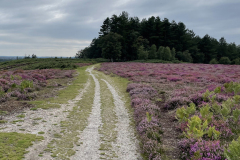
Enjoy the wide open heathland and views over the New Forest’s Northern Commons and discover a relic of the forest’s role in World War Two. In late summer you’ll be walking through a sea of pink and purple heathers which is a truly spectacular New Forest scene.
Route
Map & GPX
Information
In Pictures
Route
From the National Trust’s Rockford Common car park – situated beside a giant pit that was used to extract sand in the 1950s – head down the hill, cross the road and the ford through Dockens Water. There is a footbridge if the ford cannot be crossed.
You’ll pass the remains of an ancient oak tree on the crossroads known as the Moyles Court Oak. It is marked on an 1872 map as the ‘King of the Forest’.
Advertisement
Walk 300m along the roadside, passing Moyles Court on your left. The current red brick house dates from the 17th Century when it was the manor house of the Lisle Family. In 1685, 70-year-old Dame Alice Lisle was famously sentenced and beheaded for treason for harbouring two rebels opposed to James II. The house was confiscated by the Crown but was eventually restored to the Lisle family in 1688. Alice Lisle is buried in nearby Ellingham Church and the pub further along Highwood Lane bears her name.
Later, the house was used as the station headquarters for the nearby RAF Ibsley airfield during World War 2. It has been an independent school since 1946.
Go through the kissing gate opposite the school. Pass through another gate and walk up the narrow track alongside the paddocks.
When you reach another gate at the top of the bank, turn left and follow the path as it skirts the edge of the woodland. This section of the route is also part of the long-distance Avon Valley Path which runs from Salisbury to Christchurch.
After 250m, go through the gate ahead and enter Ibsley Common. Keeping the fence line on your left, follow the track that runs along the edge of the common. Looking out over the fields to your left you’ll see Mockbeggar Lake and Ibsley Water.
Follow this path for about 500m. Then cross the ditch via the boardwalk and footbridge, go straight across Mockbeggar Lane and up the other side of the bank, still following the Avon Valley Path.
Stick to the contour of the hillside, keeping the houses on your left, and continue until you reach a track ending in a junction at the bottom of Newtown Lane. Turn right and walk up the bank past a barrier back on to Ibsley Common.
After about 100m take the path fork to the left.
Continue straight across the heath for about 1km, taking in the vast expanse and views across the valleys in all directions. The path eventually reaches a dog leg to the right.
A few metres away to your left is the remains of a World War 2 RAF ‘Huff Duff’ station. Huff Duff stood for High Frequency Direction Finding Station – it was one of a network of top secret facilities that could transmit a homing signal to guide aircraft safely in to land. The original tower was three stories high, but the octagonal blast wall is now all that remains.
Continue on the path taking a dog leg to the right and continue for 630m back towards the trees at the small Whitefield Plantation.
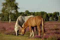
Walk for another 350m until you pass a pond in a dip on your right where New Forest ponies gather to drink and bathe – this can be a real picture postcard scene.
Instead of following the path into the trees, take a small track away from the pond and join the main gravel path across the open heath land for 800m until you reach the trees of Newlands Plantation. The path has beautiful views across the valley on the left towards Rockford Common and overlooking the Avon Valley on your right.
The path heads quite steeply downhill. At the bottom of the hill, exit through the five bar gate, turn right and walk the short distance along the tree line before cutting back down the path through the paddocks and retracing your steps to the ford and the car park.
Advertisement
View Map
Download GPX
Download PDF Guide
Essential Information
Weather


