Brockenhurst – Roydon Woods
Starting Point
Brockenhurst Station
/// built.cable.forge
Distance
7 MILES (11KM) – Circular
Categories
This walk starts the moment you step off the train at Brockenhurst station. You’ll meet the New Forest’s famous snake catcher, explore Roydon Woods nature reserve and other forest inclosures. There are lots of steep hills and descents so you’ll get plenty of exercise before you end up back in the village of Brockenhurst for a well-deserved visit to a New Forest pub.
Route
Map & GPX
Information
In Pictures
Route
Start your walk at the car park on the southern side of Brockenhurst railway station – there is a footbridge and level crossing should you need to cross the track.
Cross the main A337 to a small path and turn left down Church Lane – there is signpost to St Nicholas’ Parish Church. The gate to the church graveyard is on your left after about 600m.
Advertisement
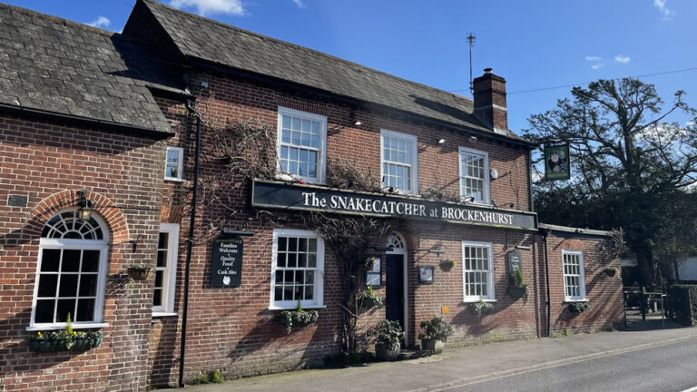
Also buried here is one of the New Forest’s most famous local characters. Henry “Brusher” Mills was a snake catcher in the forest in the 19th Century. Brusher lived in a hut deep in the forest near Brockenhurst and it’s reckoned he caught 30,000 snakes in his lifetime.
He sold many to London Zoo where they were fed to the birds of prey. Others were boiled up to make adder fat – thought to be a cure for rheumatism. Brusher’s fame spread well beyond the New Forest and Victorian visitors thronged to see him at work and would even buy snake skeletons as souvenirs.
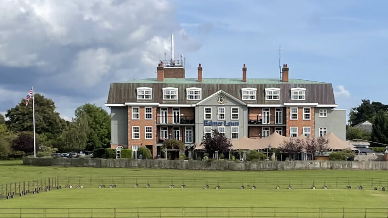
St Nicholas’ is thought to be the oldest remaining church in the forest. It was mentioned in the Doomsday Book, the survey of English land in 1086 which valued the entire village at £4. An ancient yew tree almost hides the church tower. The grey tiles on the tower were made of local clay at the Victoria Tilery at nearby Balmers Lawn.
From the church car park, continue to follow Church Lane. When you reach Beech Tree Cottage, 750m from the church, turn left down the signposted narrow bridleway.
Brockenhurst Park is now on your left. Look out for the two parallel rows of trees sweeping through the estate land. The estate was home to the Morant family from the 1760s up to the 1950s. The current estate house was built in 1960, replacing the original 18th Century building.
Eventually you will come to a gate taking you into Roydon Woods, 950 acres of protected woodland which is managed by Hampshire and Isle of Wight Wildlife Trust. As the track narrows, it heads to the right taking you through a tunnel of holly bushes.
At the bottom of the hill, cross a small stream before the path rises and falls before another steep climb. Half way up the bank you’ll go through a gate with a dedication to the memory of local naturalist Colin Tubbs.
Continue the climb through Roydon Woods past some large oak trees and silver birch trees. As the path levels out you’ll see a crater in the ground to your right which was an old gravel extraction pit. At a crossroads in the bridleway with posts to Brockenhurst and Boldre, continue straight ahead. You’ll soon pass a private gateway for the manor and a cottage called The Lodge.
After you’ve walked the length of a field on your right, you’ll come to a green five-bar gate on your left, with a Hampshire County Council Right of Way arrow post and a gas pipeline marker pole alongside it. Go through the gate and follow the path. The grand 18th Century Roydon Manor can be seen through the hedge across the field on your left.
After 200m the path drops down to a ford at the Lymington River. There’s no need to get your feet wet as there is a small footbridge.
Head up the hill through the woodland on a gravel path past a gate marked ‘private’ on the right. Continue straight ahead at the T junction with Newlands Copse on your left, following the sign for Dilton.
After a distance of about 1km from the river, you’ll come to the gate marking the end of Roydon Woods. Follow the farm track with open fields on both sides. This 500m of track can be muddy and churned up after wet weather. Just before the first farm building, follow the bridleway sign and turn left. Walk alongside the narrow track alongside a large metal farm building.
After 200m the narrow path heads steeply downhill and becomes very rocky and uneven so exercise care.
The path dips into some woodland and crosses a small stream before ascending with the open fields of Dilton Common to your right. The narrow path takes a sharp turn to the right, then again to the left. Eventually, after passing some farm buildings on your right, you’ll come out at a stretch of concrete road.
Turn left and walk the short distance towards the gate leading on to Roundhill campsite. The campsite is on the site of the former RAF base alongside edge of the Beaulieu Airfield – one of 12 around the New Forest which were built during World War Two.
Go through the gate and turn right. After 150m, follow the left fork in the path and walk 350m until you come to a large pond beside the reception kiosk. From the kiosk, follow the road out of the site and walk 700m towards the B3055 Beaulieu Road.
Cross the road and go down the path immediately opposite the entrance road to the campsite. This takes you in to New Copse Inclosure. Follow the path for 1km as it curves round to the right and reaches New Copse Cottage shortly before the railway line.
Cross the railway line and take the next gravel path on the left at Cycle Post 305. Continue on the New Forest cycle network path for 1.2km until you reach Standing Hat. Leave the inclosure and follow the straight path across Balmer Lawn which joins the Beaulieu Road and eventually comes out at the A337. Turn left and walk 1km towards the village centre and back to Brockenhurst train station.
Advertisement
View Map
Download GPX
Download PDF Guide
Essential Information
Weather

Food and Drink
In Pictures


