Rufus Stone
A walk which starts from one of the New Forest’s most famous landmarks. The Rufus Stone reputedly marks the spot where King William II – known as Rufus – was fatally struck by an arrow in 1100. The route then explores the woods and sweeping landscapes nearby.
Route
From the Rufus Stone car park, cross the road to the Rufus Stone monument.
The small, rather understated monument under an oak tree marks what is reputed to be the place where King William II – known as Rufus – was killed in a hunting accident on 2 August 1100. The cast iron monument was erected in Victorian times, placed over an original stone marker which dated from the 18th Century. However, historians believe the true location of the fatal shooting of the arrow could be near Beaulieu.
The New Forest was created as a vast royal hunting ground by Rufus’ father, William the Conquorer, in 1079. It was on a hunting trip than an arrow was fired by one of the royal party, Sir Walter Tyrell, to try and kill a deer – but it glanced off an oak tree and struck Rufus in the chest, killing him instantly.
Whether it really was an accident, or if there were more sinister reasons behind his death, it remains one of the mysteries of English history. William’s brother Henry was quick to seize the throne after his death.
The king’s body was eventually collected by a local charcoal burner called Purkis. He loaded the body onto the back of his cart and slowly carried it to Winchester. William was buried under the alter of the cathedral.
Walk along the roadside up the hill, southbound, for 300m. Turn right, past a vehicle barrier, onto the cycle path. The track joins another gravel path after 400m. Continue westbound with the A31 to your left. Although the traffic noise is present, the path does open out to some wonderful sweeping views over the northern part of the forest on your right.

After a walk of just over 1km, you’ll come to Forest Road. Turn right and walk along the roadside for 180m before joining the path to the right of the road.
Continue on the path, with the road to your left for a further 1km before it brings you out on the roadside again. Turn right immediately onto the road into Longbeech campsite.
Walk down the campsite’s concrete road – a remnant of eastern edge of the airbase that was established at Stoney Cross during World War Two.
When the concrete road ends, turn left onto the gravel path and go through the gate into Kings Garn Gutter Inclosure. Cycle marker post 28 is just the other side of the gate.
After 650m, take the gravel path on the right. Continue for 200m until you reach a crossroads and take the gravel path to the right. After 400m, turn left on to a rougher track which will take you to a gate at the edge of the inclosure.
Go through the gate and cross the small area of open lawn to the right and head down the gravel path towards the ford at a small stream at the outer perimeter of the golf course.
Advertisement
Cross the ford and continue on the path uphill with the golf course on your left. Continue for about 400m as the path passes through a tunnel of oak trees. It eventually bends round to the right and brings you out on to a country road.
Turn left and, taking care as you walk along the roadside, continue for 700m until you reach the B3078 at Brook.
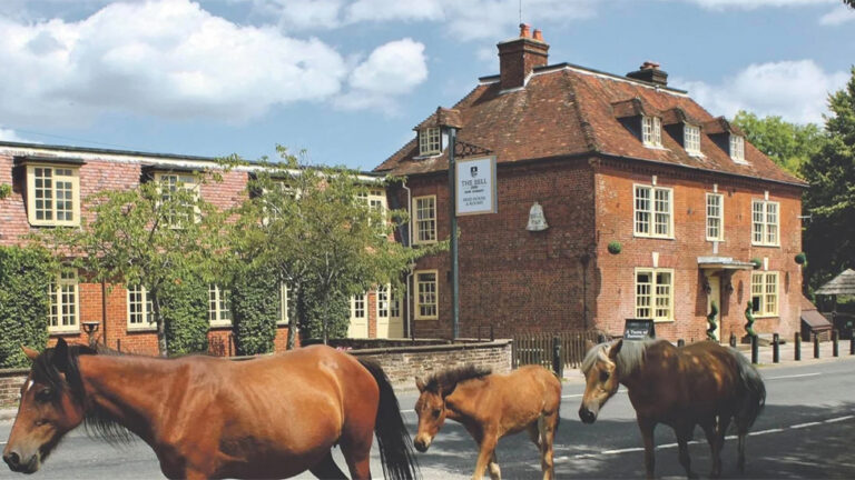
Join the footpath opposite opposite the Bell Inn and continue eastward for 250m until a fork in the road. Take the right fork down the narrower Canterton Lane, past the dead end sign.
After 700m, the road narrows and becomes a gravel track. Walk a short distance further and you’ll come to a group of houses. Take the wide path to your right and continue for 700m along the bridleway.
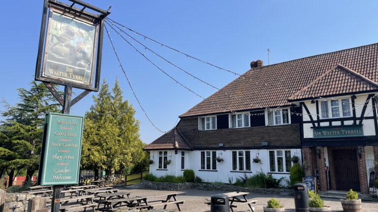
Turn left on to the road at the end of the bridleway. Taking care along the roadside, walk for 600m until you reach the Sir Walter Tyrell pub. The Rufus Stone car park is a short distance further along the road.
Advertisement
View Map
Download GPX
Essential Information
Download PDF Guide
Weather